
2011, ISBN: 0792281020
[EAN: 9780792281023], New book, [PU: NATIONAL GEOGRAPHIC MAPS DIVISION], rol map en edition. 1 pages. 46.25x35.75 inches. In Stock., Maps
| AbeBooks.com Revaluation Books, Exeter, United Kingdom [2134736] [Rating: 4 (of 5)] NEW BOOK. Frais d'envoi EUR 8.34 Details... |

ISBN: 9780792281023
No Synopsis Available North America Classic, 9780792281023, Book, Textbook Books > Education & Reference > Reference Paperback, Natl Geographic Society Maps
| BiggerBooks.com new Free shipping on orders over $79. Frais d'envoiplus shipping costs., Livraison non-comprise Details... |

2012, ISBN: 9780792281023
Wall Maps Continents, Karte/Globus, Karte (gerollt), 2017th ed. [PU: National Geographic Maps], National Geographic Maps, 2012
| lehmanns.de Frais d'envoiVersand in 10-20 Tagen. (EUR 0.00) Details... |
2011, ISBN: 0792281020
[EAN: 9780792281023], Used, as new, [PU: National Geographic Maps 2011-01-01], Books is in new condition.
| AbeBooks.com LowKeyBooks, Sumas, WA, U.S.A. [65875000] [Rating: 4 (of 5)] NOT NEW BOOK. Frais d'envoi EUR 65.47 Details... |

2005, ISBN: 9780792281023
Student ed., Karte (gerollt), Karte/Globus, [PU: National Geographic Maps]
| lehmanns.de Frais d'envoiVersand in 7-9 Tagen, , No shipping costs within Germany. (EUR 0.00) Details... |


2011, ISBN: 0792281020
[EAN: 9780792281023], New book, [PU: NATIONAL GEOGRAPHIC MAPS DIVISION], rol map en edition. 1 pages. 46.25x35.75 inches. In Stock., Maps


ISBN: 9780792281023
No Synopsis Available North America Classic, 9780792281023, Book, Textbook Books > Education & Reference > Reference Paperback, Natl Geographic Society Maps

2012
ISBN: 9780792281023
Wall Maps Continents, Karte/Globus, Karte (gerollt), 2017th ed. [PU: National Geographic Maps], National Geographic Maps, 2012
2011, ISBN: 0792281020
[EAN: 9780792281023], Used, as new, [PU: National Geographic Maps 2011-01-01], Books is in new condition.
2005, ISBN: 9780792281023
Student ed., Karte (gerollt), Karte/Globus, [PU: National Geographic Maps]
Données bibliographiques du meilleur livre correspondant
| Auteur: | |
| Titre: | |
| ISBN: |
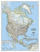
From the far northern reaches of the Arctic Sea to the Isthmus of Panama, this Classic style political map of North America features trademark National Geographic detail and accuracy. The bright color palette features blue oceans and stunning shaded relief that has been a signature of National Geographic wall maps for over 75 years. Political boundaries are clearly defined, and place names, airports, major roadways, and other geographical features are easy to read. In addition to Canada, the United States, Mexico, and Central America, coverage includes Iceland, Greenland, the island nations of the Caribbean, Venezuela, and most of Colombia. An inset map shows the Aleutian Islands off the coast of Alaska.
Enlarged maps provide an immersive experience in any home or office environment. The exceptional cartography is even easier to appreciate at the larger size. The map is packaged in a two inch diamater clear plastic tube. The tube has a decorative label showing a thumbnail of the map with dimensions and other pertinent information.
Map Scale = 1:18,950,000Sheet Size = 35.75" x 46.25"Informations détaillées sur le livre - North America Classic, Enlarged &, Tubed
EAN (ISBN-13): 9780792281023
ISBN (ISBN-10): 0792281020
Livre de poche
Date de parution: 2017
Editeur: National Geographic Maps
Livre dans la base de données depuis 2009-01-16T23:01:24+01:00 (Paris)
Page de détail modifiée en dernier sur 2022-05-20T15:25:11+02:00 (Paris)
ISBN/EAN: 0792281020
ISBN - Autres types d'écriture:
0-7922-8102-0, 978-0-7922-8102-3
Autres types d'écriture et termes associés:
Titre du livre: north america political map
Autres livres qui pourraient ressembler au livre recherché:
Dernier livre similaire:
9780792250173 North America Classic, Laminated (National Geographic Maps)
< pour archiver...